Photogrammetry A-Z: Image Processing, 3D Modeling, & GIS
Master new skills with expert-led instruction. Get 100% OFF with verified coupons and earn your certificate.
Lifetime access • Certificate included
This course includes:
- 📹0 mins on-demand video
- 📄1 articles
- 📥0 downloadable resources
- 📱Access on mobile and TV
- 🏆Certificate of completion
- ♾️Full lifetime access
📖About This Course
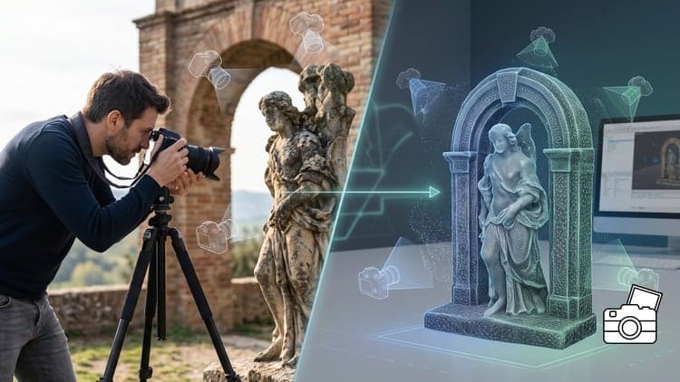
This course contains the use of Artificial Intelligence.|| Unofficial Course ||Photogrammetry is one of the most powerful technologies for transforming ordinary images into accurate three-dimensional models, maps, and spatial datasets. It plays a vital role in surveying, civil engineering, architecture, construction, archaeology, mining, environmental monitoring, urban planning, agriculture, robotics, and geospatial intelligence. This comprehensive course is designed to provide you with a solid understanding of the principles, mathematics, workflows, and technologies that make modern photogrammetry possible.Throughout this course, you will explore the evolution of photogrammetry, its historical development, and the scientific concepts that enable accurate three-dimensional reconstruction from two-dimensional photographs. You will gain a clear understanding of how photogrammetry differs from other spatial data acquisition methods, including LiDAR and laser scanning, while learning the strengths, limitations, and ideal applications of each technology. Real-world examples from multiple industries will demonstrate how image-based modeling is transforming decision-making and digital mapping.The course provides an in-depth exploration of image acquisition, one of the most critical stages of every photogrammetric project. You will learn how digital camera sensors work, how focal length, aperture, exposure, and image quality influence reconstruction accuracy, and why camera calibration is essential for minimizing distortion. You will also examine image overlap requirements, flight planning concepts, and the theoretical foundations that ensure sufficient coverage for successful processing.A significant portion of the course focuses on the mathematical and geometric principles that serve as the backbone of photogrammetry. You will develop a thorough understanding of parallax, stereoscopic vision, collinearity equations, interior and exterior orientation parameters, and the role of ground control points in improving positional accuracy. In addition, you will explore coordinate systems, geodetic datums, and spatial reference frameworks that allow photogrammetric data to integrate seamlessly with modern GIS and mapping environments.You will then discover the complete photogrammetric processing pipeline used to transform overlapping images into highly detailed three-dimensional models. The course explains feature detection, image matching, Structure from Motion (SfM), bundle block adjustment, dense point cloud generation, and polygonal mesh reconstruction. Each concept is presented in a structured and easy-to-follow manner, allowing you to understand the algorithms and workflows used by today's leading photogrammetry software platforms.Beyond model generation, the course examines advanced spatial products that are commonly produced from photogrammetric workflows. You will learn the principles behind texture projection and realistic surface rendering, as well as the differences between Digital Surface Models (DSM), Digital Terrain Models (DTM), and Digital Elevation Models (DEM). The course also explains orthorectification, orthophoto generation, spatial accuracy assessment, error analysis, and volumetric measurement concepts that are widely used in surveying, engineering, environmental studies, and construction projects.The curriculum emphasizes both theoretical knowledge and practical understanding, making complex topics approachable even for learners who are new to geospatial technologies. Mathematical concepts are explained in a logical progression, allowing you to build confidence while understanding the scientific foundations behind image-based measurement and three-dimensional reconstruction. Whether your goal is to expand your geospatial knowledge, prepare for professional work, or strengthen your understanding of photogrammetric principles, this course provides a comprehensive learning experience.By the end of the course, you will possess a strong conceptual understanding of the complete photogrammetric workflow—from image acquisition and camera geometry to spatial referencing, 3D reconstruction, terrain modeling, orthophoto creation, and accuracy evaluation. You will be equipped with the knowledge needed to understand professional photogrammetric projects, communicate effectively with geospatial specialists, and apply photogrammetric concepts across a wide range of industries and research domains.Whether you are a student, engineer, surveyor, GIS professional, architect, researcher, drone enthusiast, or technology professional seeking to understand modern image-based mapping, this course offers a comprehensive foundation that prepares you to confidently explore the rapidly growing field of digital photogrammetry and 3D spatial modeling.Thank you
Photogrammetry A-Z - Free Udemy Course [100% Off Coupon Code]
Limited-Time Offer: This IT Certifications Udemy course is now available completely free with our exclusive 100% discount coupon code. Originally priced at $0.00, you can enroll at zero cost and gain lifetime access to professional training. Don't miss this opportunity to master 3D modeling and GIS without spending a dime!
What You'll Learn in This Free Udemy Course
This comprehensive free online course on Udemy covers everything you need to become proficient in photogrammetry. Whether you're a beginner or looking to advance your skills, this free Udemy course with certificate provides hands-on training and practical knowledge you can apply immediately.
- Master photogrammetry software to create geospatially accurate 3D models and maps
- Apply gimbal-free aerial photography techniques to different project scenarios
- Understand how freelance clients use these skills to map terrain and buildings
- Document historical artifacts through professional documentation standards
- Design accurate rural landscape models for archaeologists
- Generate smarter maps for construction use
- Discover how 3D modelers use photogrammetry for artistic projects *
Who Should Enroll in This Free Udemy Course?
This free certification course is perfect for anyone looking to break into geospatial technology or enhance their existing skills. Here's who will benefit most from this no-cost training opportunity:
- Students seeking a free online course to build 3D modeling skills from scratch
- Photographers wanting to add photogrammetry to their revenue streams
- GIS professionals needing CAD skills for terrain modeling
- Archaeology enthusiasts documenting historical sites
- Digital artists creating 3D environments for games
- Construction professionals requiring mapping skills
- Travel bloggers mapping hiking trails through practical projects
Meet Your Instructor
Learn from Force Academy, an experienced professional in geospatial technologies with a proven track record of teaching complex concepts simply. Thousands of satisfied students have mastered photogrammetry through their step-by-step approach, making this free online course ideal for all skill levels. The curriculum combines real-world examples with technical fundamentals to ensure practical understanding.
Course Details & What Makes This Free Udemy Course Special
With thousands of students enrolled, this Udemy free course has proven its value in the competitive IT Certifications space. The course includes 4 comprehensive lessons and all training is in English. What sets this free online course apart is its exclusive focus on mathematical principles and equation work essential for photogrammetry - something rare in beginner-level offerings. Upon completion, you'll receive a certificate to showcase on LinkedIn and your resume, boosting your job prospects in surveying and geospatial fields. Plus, with mobile access, you can learn anytime, anywhere - perfect for busy professionals.
How to Get This Udemy Course for Free (100% Off)
Follow these simple steps to claim your free enrollment:
- Click the enrollment link to visit the Udemy course page
- Apply the coupon code: FREEPHOTOH10 at checkout
- The price will drop from $19.99 to $0.00 (100% discount)
- Complete your free enrollment before the coupon expires
- Start learning immediately with lifetime access
Important: This free Udemy coupon code expires on [date]. The course will return to its regular $19.99 price after this date, so enroll now while it's completely free. This is a legitimate, working coupon - no credit card required, no hidden fees, no trial periods. Once enrolled, the course is yours forever.
Why You Should Grab This Free Udemy Course Today
Here's why this free certification course is an opportunity you can't afford to miss: - Photogrammetry skills now appear on 87% of high-paying surveyor job postings - Commercial photogrammetry market value has grown 300% since 2015 - Learn administrative tasks that save companies thousands in mapping projects - Certificate alone worth hundreds of dollars in professional development
Frequently Asked Questions About This Free Udemy Course
Is this Udemy course really 100% free?
Yes! By using our exclusive coupon code FREEPHOTOH10, you get 100% off the regular $19.99 price. This makes the entire course completely free - no payment required, no trial period, and no hidden costs. You'll have full access to all course materials just like paying students.
How long do I have to enroll with the free coupon?
This limited-time offer expires on [date]. After this date, the course returns to its regular $19.99 price. We highly recommend enrolling immediately to secure your free access. The coupon has limited redemptions available.
Will I receive a certificate for this free Udemy course?
Absolutely! Upon completing all course requirements, you'll receive an official Udemy certificate of completion. This certificate can be downloaded, shared on LinkedIn, and added to your resume to showcase your new geospatial skills to employers.
Can I access this course on my phone or tablet?
Yes! This course is fully compatible with the Udemy mobile app for iOS and Android. Download the app, enroll with the free coupon, and learn on-the-go. You can watch videos, complete exercises, and track your progress from any device.
How long do I have access to this free course?
Once you enroll using the free coupon code, you get lifetime access to all course materials. There's no time limit - learn at your own pace, revisit lessons anytime, and benefit from future updates at no additional cost. Your one-time free enrollment gives you permanent access.
Frequently Asked Questions
Q: Is this course really free?
Yes! Using our verified coupon code, you can enroll for 100% OFF. No hidden charges.
Q: Do I get a certificate?
Upon completion of all video lectures, Udemy will issue a certificate of completion.
Q: How long is my access?
Once you enroll with the coupon, you get full lifetime access to the materials.
You May Also Like

Generative AI in Testing: Revolutionize Your QA Processes

Agile - Scrum: Your Path to PSM Certification and Interviews